
Portal:World
The World Portal


The world is the totality of entities, the whole of reality, or everything that exists. The nature of the world has been conceptualized differently in different fields. Some conceptions see the world as unique while others talk of a "plurality of worlds". Some treat the world as one simple object while others analyze the world as a complex made up of parts.
In scientific cosmology, the world or universe is commonly defined as "[t]he totality of all space and time; all that is, has been, and will be". Theories of modality talk of possible worlds as complete and consistent ways how things could have been. Phenomenology, starting from the horizon of co-given objects present in the periphery of every experience, defines the world as the biggest horizon or the "horizon of all horizons". In philosophy of mind, the world is contrasted with the mind as that which is represented by the mind. Theology conceptualizes the world in relation to God, for example, as God's creation, as identical to God or as the two being interdependent. In religions, there is a tendency to downgrade the material or sensory world in favor of a spiritual world to be sought through religious practice. A comprehensive representation of the world and our place in it, as is found in religions, is known as a worldview. Cosmogony is the field that studies the origin or creation of the world while eschatology refers to the science or doctrine of the last things or of the end of the world.
In various contexts, the term "world" takes a more restricted meaning associated, for example, with the Earth and all life on it, with humanity as a whole or with an international or intercontinental scope. In this sense, world history refers to the history of humanity as a whole and world politics is the discipline of political science studying issues that transcend nations and continents. Other examples include terms such as "world religion", "world language", "world government", "world war", "world population", "world economy", or "world championship". (Full article...)
Selected articles -
-

The retreat of glaciers since 1850 is well documented and is one of the effects of climate change. The retreat of mountain glaciers provide evidence for the rise in global temperatures since the late 19th century. Examples include mountain glaciers in western North America, Asia, the Alps in central Europe and tropical and subtropical regions of South America and Africa. Since glacial mass is affected by long-term climatic changes, e.g., precipitation, mean temperature, and cloud cover, glacial mass changes are one of the most sensitive indicators of climate change. Retreat of glaciers is also a major reason for sea level rise. Excluding peripheral glaciers of ice sheets, the total cumulated global glacial losses over the 26-year period from 1993 to 2018 were likely 5500 gigatons, or 210 gigatons per yr.
On Earth, 99% of glacial ice is contained within vast ice sheets (also known as "continental glaciers") in the polar regions. Glaciers also exist in mountain ranges on every continent other than the Australian mainland, including Oceania's high-latitude oceanic island countries such as New Zealand. Glacial bodies larger than 50,000 km2 (19,000 sq mi) are called ice sheets. They are several kilometers deep and obscure the underlying topography. (Full article...) -
The Intergovernmental Panel on Climate Change (IPCC) is an intergovernmental body of the United Nations. Its job is to advance scientific knowledge about climate change caused by human activities. The World Meteorological Organization (WMO) and the United Nations Environment Programme (UNEP) set up the IPCC in 1988. The United Nations endorsed the creation of the IPCC later that year. It has a secretariat in Geneva, Switzerland, hosted by the WMO. It has 195 member states who govern the IPCC. The member states elect a bureau of scientists to serve through an assessment cycle. A cycle is usually six to seven years. The bureau selects experts in their fields to prepare IPCC reports. There is a formal nomination process by governments and observer organizations to find these experts. The IPCC has three working groups and a task force, which carry out its scientific work.
The IPCC informs governments about the state of knowledge of climate change. It does this by examining all the relevant scientific literature on the subject. This includes the natural, economic and social impacts and risks. It also covers possible response options. The IPCC does not conduct its own original research. It aims to be objective and comprehensive. Thousands of scientists and other experts volunteer to review the publications. They compile key findings into "Assessment Reports" for policymakers and the general public; Experts have described this work as the biggest peer review process in the scientific community. (Full article...) -
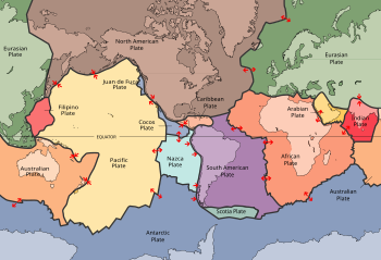
Plates in the crust of Earth
Earth's crust is its thick outer shell of rock, referring to less than one percent of the planet's radius and volume. It is the top component of the lithosphere, a division of Earth's layers that includes the crust and the upper part of the mantle. The lithosphere is broken into tectonic plates whose motion allows heat to escape the interior of Earth into space.
The crust lies on top of the mantle, a configuration that is stable because the upper mantle is made of peridotite and is therefore significantly denser than the crust. The boundary between the crust and mantle is conventionally placed at the Mohorovičić discontinuity, a boundary defined by a contrast in seismic velocity. (Full article...) -
The Global Positioning System (GPS), originally Navstar GPS, is a satellite-based radio navigation system owned by the United States government and operated by the United States Space Force. It is one of the global navigation satellite systems (GNSS) that provide geolocation and time information to a GPS receiver anywhere on or near the Earth where there is an unobstructed line of sight to four or more GPS satellites. It does not require the user to transmit any data, and operates independently of any telephone or Internet reception, though these technologies can enhance the usefulness of the GPS positioning information. It provides critical positioning capabilities to military, civil, and commercial users around the world. Although the United States government created, controls and maintains the GPS system, it is freely accessible to anyone with a GPS receiver. (Full article...) -
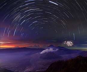
A timelapse composite panorama of different natural phenomena and environments around Mount Bromo, Indonesia.
Nature is an inherent character or constitution, particularly of the ecosphere or the universe as a whole. In this general sense nature refers to the laws, elements and phenomena of the physical world, including life. Although humans are part of nature, human activity or humans as a whole are often described as at times at odds, or outright separate and even superior to nature.
During the advent of modern scientific method in the last several centuries, nature became the passive reality, organized and moved by divine laws. With the Industrial revolution, nature increasingly became seen as the part of reality deprived from intentional intervention: it was hence considered as sacred by some traditions (Rousseau, American transcendentalism) or a mere decorum for divine providence or human history (Hegel, Marx). However, a vitalist vision of nature, closer to the pre-Socratic one, got reborn at the same time, especially after Charles Darwin. (Full article...) -

The League of Nations (French: Société des Nations [sɔsjete de nɑsjɔ̃]) was the first worldwide intergovernmental organisation whose principal mission was to maintain world peace. It was founded on 10 January 1920 by the Paris Peace Conference that ended the First World War. The main organization ceased operations on 18 April 1946 when many of its components were relocated into the new United Nations. As the template for modern global governance, the League profoundly shaped the modern world.
The League's primary goals were stated in its eponymous Covenant. They included preventing wars through collective security and disarmament and settling international disputes through negotiation and arbitration. Its other concerns included labour conditions, just treatment of native inhabitants, human and drug trafficking, the arms trade, global health, prisoners of war, and protection of minorities in Europe. The Covenant of the League of Nations was signed on 28 June 1919 as Part I of the Treaty of Versailles, and it became effective with the rest of the Treaty on 10 January 1920. Australia was granted the right to participate as an autonomous member nation, marking the start of Australian independence on the global stage. The first meeting of the Council of the League took place on 16 January 1920, and the first meeting of the Assembly of the League took place on 15 November 1920. In 1919, U.S. president Woodrow Wilson won the Nobel Peace Prize for his role as the leading architect of the League. (Full article...) -
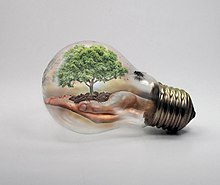
Hands holding a tree inside of a light bulb
Action for Climate Empowerment (ACE) is a term adopted by the United Nations Framework Convention on Climate Change (UNFCCC). It refers to Article 6 of the Convention's original text (1992), focusing on six priority areas: education, training, public awareness, public participation, public access to information, and international cooperation on these issues. The implementation of all six areas has been identified as the pivotal factor for everyone to understand and participate in solving the complex challenges presented by climate change. The importance of ACE is reflected in other international frameworks such as the Sustainable Development Goals (SDGs, 2015); the Global Action Programme for Education for Sustainable Development (GAP on ESD, 2014); the Aarhus Convention (2011); the Escazú Agreement (2018) and the Bali Guidelines (2010).
ACE calls on governments to develop and implement educational and public awareness programmes, train scientific, technical and managerial personnel, foster access to information, and promote public participation in addressing climate change and its effects. It also urges countries to cooperate in this process, by exchanging good practices and lessons learned, and strengthening national institutions. This wide scope of activities is guided by specific objectives that, together, are seen as crucial for effectively implementing climate adaptation and mitigation actions, and for achieving the ultimate objective of the UNFCCC. (Full article...)


.svg)

General images -
-
 View of Earth from the Moon by the Lunar Reconnaissance Orbiter (from Earth)
 -
 Dinosaurs were the dominant terrestrial vertebrates throughout most of the Mesozoic (from History of Earth)
 -
 A 2012 artistic impression of the early Solar System's protoplanetary disk from which Earth and other Solar System bodies were formed (from Earth)
 -
 Lithified stromatolites on the shores of Lake Thetis, Western Australia. Archean stromatolites are the first direct fossil traces of life on Earth. (from History of Earth)
 -
 Ajloun Castle, Jordan
 -
 Standing Buddha from Gandhara, 2nd century CE
 -
 Artist's impression of Earth during the later Archean, the largely cooled planetary crust and water-rich barren surface, marked by volcanoes and continents, features already round microbialites. The Moon, still orbiting Earth much closer than today and still dominating Earth's sky, produced strong tides. (from History of Earth)
 -
An artist's impression of the Archean, the eon after Earth's formation, featuring round stromatolites, which are early oxygen-producing forms of life from billions of years ago. After the Late Heavy Bombardment, Earth's crust had cooled, its water-rich barren surface is marked by continents and volcanoes, with the Moon still orbiting Earth half as far as it is today, appearing 2.8 times larger and producing strong tides. (from Earth)
-
 Graph showing range of estimated partial pressure of atmospheric oxygen through geologic time (from History of Earth)
 -
 Machu Picchu, Inca Empire, Peru
 -
 A reconstruction of Pannotia (550 Ma). (from History of Earth)
 -
 Artist's conception of Devonian flora (from History of Earth)
 -
 An artist's rendering of a protoplanetary disk (from History of Earth)
 -

-
 Chloroplasts in the cells of a moss (from History of Earth)
 -
 Battle during the 1281 Mongol invasion of Japan
 -

-
 Pangaea was a supercontinent that existed from about 300 to 180 Ma. The outlines of the modern continents and other landmasses are indicated on this map. (from History of Earth)
 -
 Earth's history with time-spans of the eons to scale (from History of Earth)
 -
 "Lucy", the first Australopithecus afarensis skeleton found, was only 1.06 m (3 ft 6 in) tall.
 -

-
 A 580 million year old fossil of Spriggina floundensi, an animal from the Ediacaran period. Such life forms could have been ancestors to the many new forms that originated in the Cambrian Explosion. (from History of Earth)
 -

-

-
 Persepolis, Achaemenid Empire, 6th century BCE
 -
 First airplane, the Wright Flyer, flew on 17 December 1903.
 -

-
 A schematic view of Earth's magnetosphere with solar wind flowing from left to right (from Earth)
 -
 Change in average surface air temperature and drivers for that change. Human activity has caused increased temperatures, with natural forces adding some variability. (from Earth)
 -

-
 Olmec colossal head, now at the Museo de Antropología de Xalapa
 -
 Yggdrasil, an attempt to reconstruct the Norse world tree which connects the heavens, the world, and the underworld. (from World)
 -

-
 A computer-generated image mapping the prevalence of artificial satellites and space debris around Earth in geosynchronous and low Earth orbit (from Earth)
 -

-
 Artist's conception of Hadean Eon Earth, when it was much hotter and inhospitable to all forms of life. (from History of Earth)
 -
 Notre-Dame de Paris, France
 -
 Great Mosque of Kairouan, Tunisia, founded 670 CE
 -
 Fall of the Berlin Wall, 1989
 -
 Vitruvian Man by Leonardo da Vinci epitomizes the advances in art and science seen during the Renaissance. (from History of Earth)
 -
 Earth's western hemisphere showing topography relative to Earth's center instead of to mean sea level, as in common topographic maps (from Earth)
 -
 A reconstruction of human history based on fossil data. (from History of Earth)
 -
 Shanghai. China urbanized rapidly in the 21st century.
 -
 A banded iron formation from the 3.15 Ga Moodies Group, Barberton Greenstone Belt, South Africa. Red layers represent the times when oxygen was available; gray layers were formed in anoxic circumstances. (from History of Earth)
 -
 Ming dynasty section, Great Wall of China
 -
 Satellite time lapse imagery of Earth's rotation showing axis tilt (from Earth)
 -
 Artist's rendition of an oxinated fully-frozen Snowball Earth with no remaining liquid surface water. (from History of Earth)
 -
 Tiktaalik, a fish with limb-like fins and a predecessor of tetrapods. Reconstruction from fossils about 375 million years old. (from History of Earth)
 -

-
 Cross-section through a liposome (from History of Earth)
 -

-
 Great Pyramids of Giza, Egypt
 -
 Peopling of the world, the Southern Dispersal scenario
 -
 Earth's night-side upper atmosphere appearing from the bottom as bands of afterglow illuminating the troposphere in orange with silhouettes of clouds, and the stratosphere in white and blue. Next the mesosphere (pink area) extends to the orange and faintly green line of the lowest airglow, at about one hundred kilometers at the edge of space and the lower edge of the thermosphere (invisible). Continuing with green and red bands of aurorae stretching over several hundred kilometers. (from Earth)
 -

-
 Florence, birthplace of the Italian Renaissance
 -
 Artist's impression of the enormous collision that probably formed the Moon (from History of Earth)
 -
 Benin Bronze head from Nigeria
 -

-
 The replicator in virtually all known life is deoxyribonucleic acid. DNA is far more complex than the original replicator and its replication systems are highly elaborate. (from History of Earth)
 -
 Chennakesava Temple, Belur, India
 -
 Taj Mahal, Mughal Empire, India
 -
 Artist's impression of a Hadean landscape with the relatively newly formed Moon still looming closely over Earth and both bodies sustaining strong volcanism. (from History of Earth)
 -
 Geologic map of North America, color-coded by age. From most recent to oldest, age is indicated by yellow, green, blue, and red. The reds and pinks indicate rock from the Archean.
 -
 Image of the physical world, captured by the Hubble Space Telescope (from World)
 -

-

-
 A map of heat flow from Earth's interior to the surface of Earth's crust, mostly along the oceanic ridges (from Earth)
 -
 Earth's land use for human agriculture in 2019 (from Earth)
 -
 Trilobites first appeared during the Cambrian period and were among the most widespread and diverse groups of Paleozoic organisms. (from History of Earth)
 -
 Angkor Wat temple complex, Cambodia, early 12th century
 -
 Last Moon landing: Apollo 17 (1972)
 -
 Obelisk of Axum, Ethiopia
 -

-
 An artist's impression of ice age Earth at glacial maximum. (from History of Earth)
 -
 A view of Earth with different layers of its atmosphere visible: the troposphere with its clouds casting shadows, a band of stratospheric blue sky at the horizon, and a line of green airglow of the lower thermosphere around an altitude of 100 km, at the edge of space (from Earth)
 -
 A pillar at Göbekli Tepe
 -

-
 A composite image of Earth, with its different types of surface discernible: Earth's surface dominating Ocean (blue), Africa with lush (green) to dry (brown) land and Earth's polar ice in the form of Antarctic sea ice (grey) covering the Antarctic or Southern Ocean and the Antarctic ice sheet (white) covering Antarctica. (from Earth)
 -
 Tracy Caldwell Dyson, a NASA astronaut, observing Earth from the Cupola module at the International Space Station on 11 September 2010 (from Earth)
 -
 Pale orange dot, an artist's impression of Early Earth, featuring its tinted orange methane-rich early atmosphere (from Earth)
 -
 A view of Earth with its global ocean and cloud cover, which dominate Earth's surface and hydrosphere; at Earth's polar regions, its hydrosphere forms larger areas of ice cover. (from Earth)
 -
The pale orange dot, an artist's impression of the early Earth which might have appeared orange through its hazy methane rich prebiotic second atmosphere. Earth's atmosphere at this stage was somewhat comparable to today's atmosphere of Titan. (from History of Earth)
-
 A composite image of artificial light emissions at night on a map of Earth (from Earth)
 -
 Earth's axial tilt causing different angles of seasonal illumination at different orbital positions around the Sun (from Earth)
 -
 Japanese depiction of a Portuguese carrack. European maritime innovations led to proto-globalization.
 -
 Empires of the world in 1898
 -
 An animation of the changing density of productive vegetation on land (low in brown; heavy in dark green) and phytoplankton at the ocean surface (low in purple; high in yellow) (from Earth)


.jpeg)


.svg)


.jpg)


.jpg)


.jpg)


Megacities of the world -
.JPG)
Karachi (/kəˈrɑːtʃi/; Urdu: کراچی; Sindhi: ڪراچي; IPA: [kəˈraːtʃi] ) is the capital city of the Pakistani province of Sindh. It is the largest city in Pakistan and the 12th largest in the world, with a population of over 20 million. It is situated at the southern tip of the country along the Arabian Sea coast and formerly served as the capital of Pakistan. Ranked as a beta-global city, it is Pakistan's premier industrial and financial centre, with an estimated GDP of over $200 billion (PPP) . Karachi is a metropolitan city and is considered Pakistan's most cosmopolitan city, and among the country's most linguistically, ethnically-, and religiously-diverse regions, as well as one of the country's most progressive and socially liberal cities.
The region has been inhabited for millennia, but the city was formally founded as the fortified village of Kolachi as recently as 1729. The settlement greatly increased in importance with the arrival of the East India Company in the mid-19th century. British administrators embarked on substantial projects to transform the city into a major seaport, and connect it with the extensive railway network of the Indian subcontinent. At the time of Pakistan's independence in 1947, the city was the largest in Sindh with an estimated population of 400,000 people. Afterwards, the city experienced a dramatic shift in population and demography with the arrival of hundreds of thousands of Muslim immigrants (Muhajirs) from India, coupled with a substantial exodus of its Hindu residents. The city experienced rapid economic growth following Pakistan's independence, attracting migrants from throughout the country and other regions in South Asia. According to the 2023 Census of Pakistan, Karachi's total population was 20.3 million. Karachi is one of the world's fastest-growing cities, and has significant communities representing almost every ethnic group in Pakistan. Karachi holds more than two million Bengali immigrants, a million Afghan refugees, and up to 400,000 Rohingyas from Myanmar. (Full article...)Did you know -

- ... that the Indonesian film Apa Jang Kau Tjari, Palupi? was "hailed by critics", "rejected by the audience", and "shown around the world"?
- ... that Fred J. Wiseman delivered the world's first unofficial airmail flight by airplane?
- ... that actress Klara Höfels, known for her roles in television crime series, also produced, directed, and starred in world premieres of theatre projects in Berlin?
- ... that City Pier A's clock tower was the first memorial to World War I casualties in the United States, according to a New York City government spokesperson?
- ... that the cherry blossom was used symbolically in Japanese World War II propaganda, with falling petals representing "young soldiers' sacrifice for the emperor"?
- ... that during the 1916–1917 northern Minnesota lumber strike, multiple cities in Minnesota banned members of the Industrial Workers of the World from their municipalities?
- ... that Turkish world- and European-champion armwrestler Esra Kiraz used to carry cement bags at construction sites where her father worked?
- ... that an observer once described a play-by-mail game as "the most complex game system on Earth"?
Countries of the world -

Sweden, formally the Kingdom of Sweden, is a Nordic country located on the Scandinavian Peninsula in Northern Europe. At 450,295 square kilometres (173,860 sq mi), Sweden is the largest Nordic country and the fifth-largest country in Europe. The capital and largest city is Stockholm. Sweden has a population of 10.5 million, and a low population density of 25.5 inhabitants per square kilometre (66/sq mi), with around 87% of Swedes residing in urban areas, which cover 1.5% of the entire land area, in the central and southern half of the country. It borders Norway to the west and north, and Finland to the east. With the country ranging from 55°N to 69°N, the climate of Sweden is diverse due to the length of the country.
Sweden has been inhabited since prehistoric times, c. 12,000 BC. The inhabitants emerged into history as the Geats (Swedish: Götar) and Swedes (Svear) and constituted the sea peoples known as the Norsemen. A unified Swedish state emerged during the late 10th century. In 1397, Sweden joined Norway and Denmark to form the Scandinavian Kalmar Union, which Sweden left in 1523. When Sweden became involved in the Thirty Years' War on the Protestant side, an expansion of its territories began, forming the Swedish Empire, which remained one of the great powers of Europe until the early 18th century. During this era Sweden controlled much of the Baltic Sea. Most of the conquered territories outside the Scandinavian Peninsula were lost during the 18th and 19th centuries. The eastern half of Sweden, present-day Finland, was lost to Imperial Russia in 1809. The last war in which Sweden was directly involved was in 1814, when Sweden by military means forced Norway into a personal union, a union which lasted until 1905. (Full article...)Related portals
Protected areas of the world -
-
-

A family of Asiatic lions at Gir National Park
The Gujarat state of western India has four National Parks and twenty-three wildlife sanctuaries which are managed by the Forest Department of the Government of Gujarat. (Full article...) -
This is a list of protected areas of Ontario that are administered by Government of Ontario. Ontario Parks and the Ministry of the Environment, Conservation and Parks are the provincial bodies responsible for managing these protected areas. (Full article...)
-

Vegetation outside Goz Beïda
The wildlife of Chad is composed of its flora and fauna. Bush elephants, West African lions, buffalo, hippopotamuses, Kordofan giraffes, antelopes, African leopards, cheetahs, hyenas, and many species of snakes are found there, although most large carnivore populations have been drastically reduced since the early 20th century. Elephant poaching, particularly in the south of the country in areas such as Zakouma National Park, is a severe problem. (Full article...) -
Protected areas of Norway include:
About 17 percent of the mainland of Norway is protected. Of this, ca. 8.3 percent is national parks, 1.3 percent is nature reserves and 4.7 percent otherwise protected. (Full article...) -
Bihar is a state in East India. It is bounded by Uttar Pradesh to the west, Nepal to the north, West Bengal to the east and Jharkhand to the south. About 7% of the state is protected forest area. (Full article...)
-
Desert landscape in Qatar
Protected areas of Qatar include:- Al Reem Biosphere Preserve (designated in 2007) is part of the World Network of Biosphere Reserves in the Arab States
- Al Shahaniyah Park in Al-Shahaniya
- Al Thakira Nature Reserve in Al Thakhira
- Al Wabra Wildlife Preservation
- Dahl Al Hammam Park, a sinkhole in Doha (entrance to the hole is now closed to the public)
- Khor Al Adaid Natural Reserve in Khor Al Adaid
- Khor Al Udeid Fish Sanctuary
- Mudhlem Cave in Mukaynis
- Musfer Sinkhole in Salwa
- Ras Abrouq Nature Reserve (also known as Bir Zekreet (Zekreet Beach)) in Ras Abrouq
- Ras Ushairij Gazelle Conservation Park
- Umm Tais National Park
-
-

Tijuca Forest National Park
Protected areas of Brazil included various classes of area according to the National System of Nature Conservation Units (SNUC), a formal, unified system for federal, state and municipal parks created in 2000. (Full article...) -
Protected areas of Australia include Commonwealth and off-shore protected areas managed by the Australian government, as well as protected areas within each of the six states of Australia and two self-governing territories, the Australian Capital Territory and the Northern Territory, which are managed by the eight state and territory governments.
Commonwealth and off-shore protected areas in the Australian Capital Territory, the Northern Territory, the Christmas Island Territory, the Cocos (Keeling) Islands Territory, the Norfolk Island Territory and the Australian Antarctic Territory are managed by Director of National Parks, an agency within the Department of the Environment and Energy, with the exception of the Great Barrier Reef Marine Park, which is managed by the Great Barrier Reef Marine Park Authority, a separate body within the department. (Full article...) -
Protected areas of Canada consist of approximately 12.1 percent of the nation's landmass and freshwater are considered conservation areas, including 11.4 percent designated as protected areas. Approximately 13.8 percent of Canada's territorial waters are conserved, including 8.9 percent designated as protected areas. Terrestrial areas conserved have increased by 65 percent in the 21st century, while marine areas conserved have increased by more than 3,800 percent.
Conservation and protected areas have different mandates depending on the organization which manages them, with some areas having a greater focus on ecological integrity, historical preservation, public usage, scientific research, or a combination of usages. Some areas such as the Polar Bear Pass, are co-managed and overseen by government and local indigenous agencies. (Full article...) -
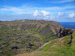
Rano Kau, Parque National Rapa Nui, Easter Island
The protected areas of Chile are areas that have natural beauty or significant historical value protected by the government of Chile. These protected areas cover over 140,000 km2 (54,054 sq mi), which is 19% of the territory of Chile. The National System of Protected Wild Areas (SNASPE by its Spanish acronym) is regulated by law #18,362 passed in 1984, and administered by the National Forest Corporation (CONAF).
There are three types of territories: (Full article...) -
Protected areas of Slovenia include one national park (Slovene: narodni park), three regional parks (regijski park), several natural parks (krajinski park), and hundreds of natural monuments (naravni spomenik) and monuments of designed nature (spomenik oblikovane narave). They cover about 12.5% of the Slovenian territory. Under the Wild Birds Directive, 26 sites totalling roughly 25% of the nation's land are "Special Protected Areas"; the Natura 2000 proposal would increase the totals to 260 sites and 32% of national territory. (Full article...)
-
-

Bonampak is an ancient Maya archaeological site in the Mexican state of Chiapas, and is a natural monument.
There are currently 225 Protected Natural Areas in Mexico, covering 93.8 million hectares in total. They are protected and administered by the National Commission of Protected Natural Areas (Comisión Nacional de Áreas Naturales Protegidas, or 'CONANP'), a federal agency. CONANP administers:- 77 Mexican National Parks
- 48 biosphere reserves
- 54 flora and fauna protection areas
- 28 Mexican Nature Sanctuaries
- 13 natural resources protection areas
- 5 natural monuments


.jpg)


Selected world maps
-
 Only a few of the largest large igneous provinces appear (coloured dark purple) on this geological map, which depicts crustal geologic provinces as seen in seismic refraction data
 -
 The Goode homolosine projection is a pseudocylindrical, equal-area, composite map projection used for world maps.
 -
 A plate tectonics map with volcano locations indicated with red circles
 -
 Mollweide projection of the world
 -
 Index map from the International Map of the World (1:1,000,000 scale)
 -
 Time zones of the world
 -
 United Nations Human Development Index map by country (2016)
 -
 The world map by Gerardus Mercator (1569), the first map in the well-known Mercator projection
 -
 1516 map of the world by Martin Waldseemüller


World records
- List of Olympic records in athletics
- List of world records in athletics
- List of junior world records in athletics
- List of world records in masters athletics
- List of world youth bests in athletics
- List of IPC world records in athletics
- List of world records in canoeing
- List of world records in chess
- List of cycling records
- List of world records in track cycling
- List of world records in finswimming
- List of world records in juggling
- List of world records in rowing
- List of world records in speed skating
- List of world records in swimming
- List of IPC world records in swimming
- List of world records in Olympic weightlifting
Topics

Continents of Earth | ||||||||
|---|---|---|---|---|---|---|---|---|
| ||||||||
| ||||||||
| ||||||||


| Cenozoic Era (present–66.0 Ma) |
| ||||||||||||
|---|---|---|---|---|---|---|---|---|---|---|---|---|---|
| Mesozoic Era (66.0–252 Ma) |
| ||||||||||||
| Paleozoic Era (252–539 Ma) |
| ||||||||||||
| Proterozoic Eon (539 Ma–2.5 Ga) |
| ||||||||||||
| Archean Eon (2.5–4 Ga) | |||||||||||||
| Hadean Eon (4–4.6 Ga) | |||||||||||||
ka = kiloannum (thousands years ago); Ma = megaannum (millions years ago); Ga = gigaannum (billions years ago). See also: Geologic time scale • | |||||||||||||
| Locations | ||
|---|---|---|
| Related | ||

| |||||||||||||||||||
| |||||||||||||||||||
| |||||||||||||||||||

Economic classification of countries | |||||
|---|---|---|---|---|---|
| Three-World Model | |||||
| Gross domestic product (GDP) |
| ||||
| Gross national income (GNI) | |||||
| Wages | |||||
| Wealth | |||||
| Other national accounts | |||||
| Human development | |||||
| Digital divide | |||||
| Net international investment position (NIIP) | |||||
| Technological |
| ||||
|---|---|---|---|---|---|
| Sociological | |||||
| Ecological |
| ||||
| Biological |
| ||||
| Astronomical | |||||
| Eschatological |
| ||||
| Others |
| ||||
| Fictional | |||||
| Organizations | |||||
Categories

Wikimedia
The following Wikimedia Foundation sister projects provide more on this subject:
-
 Commons
Free media repository -
 Wikibooks
Free textbooks and manuals -
 Wikidata
Free knowledge base -
 Wikinews
Free-content news -
 Wikiquote
Collection of quotations -
 Wikisource
Free-content library -
 Wikispecies
Directory of species -
 Wikiversity
Free learning tools -
 Wikivoyage
Free travel guide -
 Wiktionary
Dictionary and thesaurus


